
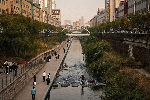
For nearly fifty years, one of central Seoul's oldest waterways existed only on old maps. Traffic ran where the water used to be — and almost nobody under forty had ever seen it.
What Was Buried Under Cheonggyecheon Before It Became a Stream?
Cheonggyecheon is a 10.84 km stream running through downtown Seoul that spent roughly five decades sealed under concrete and an elevated highway before being uncovered and reopened on 1 October 2005 . What sat on top of it was the Cheonggye Overpass, a 5.6 km elevated expressway completed by 1976 that carried about 170,000 vehicles per day .
Quick Answer: Under Cheonggyecheon sat the Cheonggye Overpass, a 5.6 km elevated expressway carrying roughly 170,000 vehicles daily. The stream had been progressively covered from 1958. A 2000–2001 safety inspection found structural cracking, the highway was demolished from 2003, and the restored stream reopened on 1 October 2005.
The burial happened in stages. After the Korean War, the banks filled with makeshift housing and waste, and from 1958 the city began covering the channel section by section, turning it into the road corridor known as Cheonggyero . The overpass followed, and for a generation the area functioned as an industrial and light-manufacturing spine rather than a waterfront.
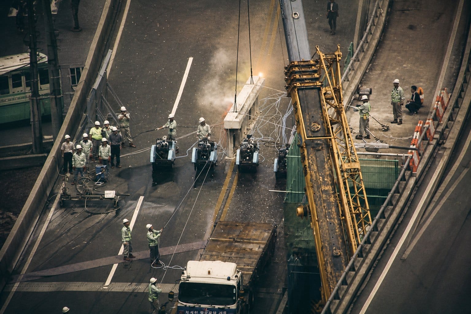
The reversal was driven less by nostalgia than by engineering. A safety inspection conducted between August 2000 and May 2001 found cracks, slab exfoliation and insufficient load capacity in the aging overpass, leaving demolition or expensive reconstruction as the only options . Restoration became the central pledge of the 2002 Seoul mayoral campaign, demolition began in 2003, and the 5.84 km restored section opened two years later — free to enter, open 24 hours, and now used by roughly 60,000 people on an average day .
From Joseon Flood Channel to Concrete Highway: The Full Timeline (1411–2005)
Cheonggyecheon's timeline runs from a Joseon-era flood-control project to a covered expressway corridor and back to an open stream in just under six centuries. The early Joseon court began engineering the natural watercourse into a managed flood channel in 1411 , covering work started in 1958, the elevated overpass opened in 1976, and the restored 5.84 km waterway reopened on 1 October 2005 after a KRW 386.739 billion build . Each phase left physical traces still visible along the walk today.
The 1411 works produced the stone bridges that anchor the stream's heritage identity, including Gwangtonggyo and Supyogyo. Gwangtonggyo was rebuilt under King Taejong, who reigned from 1400 to 1418, and the structure spent roughly a century buried beneath the road surface before being re-erected during restoration using some of its original stones . For most of the Joseon period the channel functioned as drainage infrastructure rather than scenery — a distinction that matters when reading the current landscaping, which is a 2000s design decision, not a reconstruction of a historical garden.
The covering phase tracked Seoul's postwar industrial expansion. After the Korean War the banks filled with makeshift housing and waste, and from 1958 the stream was progressively paved over, becoming the road corridor known as Cheonggyero. The Cheonggyecheon Museum treats 1958–1977 as a single exhibition period covering that covered-road industrial era . In 1976 the 5.6 km Cheonggye Overpass opened above the buried channel, and at its peak the elevated road carried roughly 170,000 vehicles a day — a volume that made any later removal a traffic-planning problem as much as an environmental one.
Structural condition, not sentiment, forced the decision. A safety inspection conducted between August 2000 and May 2001 documented cracks, slab exfoliation and insufficient load capacity in the overpass , which narrowed the realistic choices to demolition or an expensive rebuild. Restoration then became the signature pledge of the 2002 Seoul mayoral campaign, and construction ran from July 2003 to September 2005 .
The delivered scope is unusually well documented for a project of this scale. The Seoul Metropolitan Government records a budget of KRW 386.739 billion in 2005 won, producing about 20 km of trail, 10,419 light fixtures, 252,000 ㎡ of planting and a 40,000 ㎡ maintenance-water supply area . That last figure explains something walkers notice immediately: the stream is fed and maintained rather than purely natural, which is why water runs consistently even in dry months.
Cheonggyecheon Museum | 관광 (역사 전시)
The Cheonggyecheon Museum, operated under the Seoul Museum of History, organizes this exact arc into four exhibition zones — the engineering of the stream from 1411, the covered Cheonggyero road period of 1958–1977, the restoration project of 2003–2005, and post-restoration debates . The inclusion of that fourth zone is notable: the institution documenting the project also curates criticism of it, including questions about the maintenance-water system and the displacement of the merchants who had worked in the covered corridor. The museum opened on 1 October 2005, the same day the restored stream reopened to the public . Outside the building stand replica 1960s Seoul houses and shops reconstructing the streetscape that the highway era replaced.
📋 주소: 530 Cheonggyecheon-ro, Seongdong-gu, Seoul (04704) · 영업시간: 09:00–18:00 (Tue–Fri, March–October; weekends and holidays year-round), closed Mondays and 1 January · 특징: free admission, four permanent exhibition zones, tel. 02-2286-3410
💡 The museum sits downstream in Seongdong-gu, well past the standard Cheonggye Plaza–Dongdaemun tourist segment, so treat it as a separate trip rather than a stop on a short walk. Visiting before walking the restored section makes the bridges and stonework legible; going on a Monday does not work, as the museum closes.
📍 530 Cheonggyecheon-ro, Seongdong-gu, Seoul
🕒 Monday Closed / Tuesday–Sunday 9:00 AM – 6:00 PM
⭐ 4.3 (733 reviews)
📞 02-2286-3410
🔗 View on Google Maps
"The engineering of the stream from 1411, the covered road period of 1958–1977, the restoration of 2003–2005, and post-restoration debates" — the four-zone framing used by the Cheonggyecheon Museum, Seoul Museum of History (source: Seoul Museum of History, 2005-10).
Cheonggye Plaza to Dongdaemun: What's Along the Restored Walk in 2026
The Cheonggye Plaza → Dongdaemun stretch is the segment most visitors actually walk: roughly 2 km, or about 40–60 minutes at a relaxed pace with stops . Walking the full 10.9 km east to where the water meets the Jungnangcheon and the Han River takes 3–4 hours . The route is free and open 24 hours , and it runs on two levels — a sunken waterside path with stepping-stone crossings, and a street-level upper path — with stairways at nearly every block and ramps at many entry points, so a partial walk is as workable as the full one .
Cheonggye Plaza | 관광 (western trailhead)
Cheonggye Plaza is where the water starts and where most walks begin. Its centrepiece is the Candle Fountain, lit in three colours, feeding a two-tier waterfall about 4 m high; beside it sits the Palseokdam, a stone basin assembled from stones gathered across Korea's provinces, and a 1/100-scale miniature model of the entire stream that is useful for orienting yourself before you set off . The entrance marker is hard to miss: Claes Oldenburg's Spring, a 20 m red-and-blue spiral, stands at the plaza edge .
📋 주소: Taepyeong-ro 1-ga 1, Jung-gu (reference address 37 Mugyo-ro, Jongno-gu 03187) · 영업시간: 24시간, 연중무휴 · 특징: Candle Fountain, 4 m 2단 폭포, 팔석담, 1/100 축소 모형, Oldenburg Spring
💡 The plaza information centre lends umbrellas free against an ID deposit — worth knowing before a summer walk . There is no parking here, so arrive by subway or bus .
📍 1 Taepyeongno 1(il)-ga, Jung District, Seoul
🕒 Daily Open 24 hours
⭐ 4.4 (8,496 reviews)
📞 02-2290-7111
🔗 View on Google Maps
Gwangtonggyo | 관광 (Joseon stone bridge)
A few minutes downstream from the plaza, Gwangtonggyo is the first piece of original Joseon stonework on the route. The bridge was rebuilt under King Taejong (r. 1400–1418), then spent roughly a century buried under fill and pavement before being re-erected during the restoration using a portion of its original stones . Twenty-two bridges cross the stream in total, but this is the one where the seams between six-century-old stone and modern replacement are visible at eye level .
📋 위치: Cheonggyecheon-ro, near Gwangtonggyo crossing, Jung-gu · 관람: 상시 개방, 무료 · 특징: 태종代 재건 석교, 원형 석재 일부 재사용
💡 Take the lower waterside path here rather than the street-level one — the stonework and the arch underside are only legible from the sunken walkway.
📍 55-2 Seorin-dong, Jongno District, Seoul
🕒 Daily Open 24 hours
⭐ 4.6 (156 reviews)
🔗 View on Google Maps
Cheonggyecheon Museum | 관광 (downstream, past Dongdaemun)
The museum sits well east of the tourist segment, at 530 Cheonggyecheon-ro, Seongdong-gu (04704), and is the place to see the covered-highway era documented rather than described. Admission is free; hours are 09:00–18:00, closed Mondays and 1 January, tel. 02-2286-3410 . Outside stand replica 1960s Seoul houses and shopfronts, reconstructing the streetscape that stood over the buried channel before demolition .
📋 주소: 530 Cheonggyecheon-ro, Seongdong-gu 04704 · 영업시간: 09:00–18:00 (월요일·1월 1일 휴관) · 입장료: 무료 · 문의: 02-2286-3410
💡 Pair it with the walk only if you have a full afternoon — it is far past Dongdaemun. Otherwise take Line 2 to Yongdu and walk down to the stream from there .
📍 530 Cheonggyecheon-ro, Seongdong-gu, Seoul
🕒 Monday Closed / Tuesday–Sunday 9:00 AM – 6:00 PM
⭐ 4.3 (733 reviews)
📞 02-2286-3410
🔗 View on Google Maps
If 2 km is your limit, end at Dongdaemun and surface for Gwangjang Market. If you want the segment breakdown before you go, Seoul Facilities Corporation publishes bridge-to-bridge walking guides — Mojeongyo–Samilgyo, Samilgyo–Seoungyo, Seoungyo–Beodeul Bridge and onward — plus a separate route guide for mobility-impaired visitors .
Getting There from Gwanghwamun: Subway, Bus, and Walking Routes
Cheonggye Plaza, the stream's western trailhead, sits at Taepyeong-ro 1-ga 1, Jung-gu, roughly 60 m — under two minutes on foot — from Exit 5 of Gwanghwamun Station on Subway Line 5 . City Hall Station on Lines 1 and 2 is the second option, with Exit 4 measured at about 300 m by Seoul Facilities Corporation and 384 m by Visit Seoul . Either way, you arrive at street level and walk down the ramp or stairs into the sunken path — there is no ticket gate, no queue, and no opening hour to work around.
Buses stop at Seoul Sinmun-sa (stop IDs 02137 and 02706), served by routes 101, 150, 501, 506, 708, 1711, 7016 and 01A . Driving is the one approach that does not work: there is no dedicated parking at Cheonggye Plaza, which makes subway or bus effectively mandatory .
| Access point | Line(s) | Exit | Distance to Cheonggye Plaza |
|---|---|---|---|
| Gwanghwamun Station | Line 5 | Exit 5 | ~60 m (under 2 min) |
| City Hall Station | Lines 1, 2 | Exit 4 | ~300–384 m |
| Seoul Sinmun-sa bus stop | 101, 150, 501, 506, 708, 1711, 7016, 01A | Stop ID 02137 / 02706 | Adjacent to the plaza |
| Car | — | — | No dedicated parking |
You do not have to start at the western end. Eleven subway stations touch the stream across its full length: City Hall, Jonggak, Jongno 3-ga, Jongno 5-ga, Dongdaemun, Dongmyo and Sinseol-dong on Line 1, plus Euljiro 1-ga, Euljiro 3-ga, Euljiro 4-ga, Dongdaemun History & Culture Park and Yongdu on Line 2 . That density is what makes the walk flexible — pick any station along the corridor, drop down to the waterside, walk as far as your schedule allows, and climb out at the next bridge to catch a train back.
For visitors already sightseeing in the palace district, the geography does most of the planning. Cheonggye Plaza is about a five-minute walk from Gwanghwamun Square and Gyeongbokgung, so the standard half-day route runs Gyeongbokgung → Gwanghwamun Square → Cheonggye Plaza → east along the stream → Gwangjang Market or Dongdaemun . That sequence ends you at a subway hub in Dongdaemun with Lines 1, 2 and 4 within a block, which matters if you are heading on to a concert venue or an evening booking elsewhere in the city.
One practical note on timing: the corridor carries about 60,000 people on an average day , and the Gwanghwamun-to-Jongno stretch is heaviest at lunch hour on weekdays and after 18:00 in summer. Arriving before 10:00 or after 20:00 gives you the same walk with noticeably more room on the stepping stones.
When to Visit: Seasons, Hours, and the Seoul Lantern Festival
Cheonggyecheon is open 24 hours a day, year-round, with free admission, so the real planning question is season rather than opening time . The waterfall at Cheonggye Plaza runs all year, but most of the stream's fountains operate seasonally from April through November, with extended hours between May and September . That makes late spring and early autumn the fullest version of the walk, while winter trades water features for lantern lighting.
Summer has one advantage that is easy to underestimate. Because the walkway sits several metres below street level and runs alongside moving water, waterside temperatures measure noticeably cooler than the road above . In August, when central Seoul is at its most humid, the sunken path is one of the few downtown routes where a 40-minute walk is still comfortable in the late afternoon.
A quick season-by-season read:
- April–June: fountains active, planting at its greenest, mild evenings — the easiest all-round window.
- July–August: coolest option downtown during the day, but the monsoon means water levels can rise fast; check the forecast before descending to the lower path.
- September–November: fountains still running into November, lighter crowds than spring, comfortable for the full 10.9 km walk.
- December–February: no seasonal fountains, but this is lantern festival season along the Cheonggye Plaza–Samil Bridge stretch.
The winter anchor event is the Seoul Lantern Festival (서울빛초롱축제). The 17th edition ran from 12 December 2025 to 18 January 2026 between Cheonggye Plaza and Samil Bridge, free to enter, organised by the Seoul Tourism Foundation, with roughly 500 hanji-and-LED light sculptures alongside kinetic and media-art installations . The Cheonggyecheon section opened 18:00–23:00 and was extended past its originally announced 4 January closing date to 18 January 2026, with 5 January a closed day .
As of August 2026, dates for the winter 2026–27 edition have not been officially announced. Unofficial listings circulating a "1 November 2026 – 31 January 2027" run are not confirmed by the organiser, so treat them as unverified and check the official festival site at stolantern.com or the Seoul Culture Portal before booking travel around it.
Two nearby programmes give the same trip a second reason to be in the area. The 2026 Seoul Outdoor Library runs April through November roughly 80 m from Cheonggye Plaza , and the 2026 Seoul Summer Beach occupies Gwanghwamun Square and Sejongno Park from 20 July to 9 August 2026 . Outdoor programming in central Seoul can be suspended during typhoon, heavy-snow or cold-wave advisories, so confirm on Visit Seoul or by calling 02-120 on the day.
Safety, Rules, and Practical Tips for Walking the Stream
The single most important safety rule at Cheonggyecheon is that the sunken waterside walkway floods fast during rain, and the water can rise without warning — a risk concentrated in the July–August monsoon . Seoul Facilities Corporation has installed 39 emergency ladders along the channel so walkers can climb to street level quickly . If rain starts, leave the lower path at the nearest stairway rather than continuing to the next bridge.
The stream is a pedestrian corridor, not a park for recreation, and the posted prohibitions are enforced :
- No fishing — the stream is managed as a restored habitat, not a fishing spot.
- No swimming or wading beyond the stepping stones.
- No camping anywhere along the banks.
- No bicycles on the waterside walkway — ride at street level instead.
- No pets, including carried or leashed animals.
Access is easier than the sunken layout suggests. The route is doubled — a waterside walkway below and a street-level upper path above — with stairways at almost every block and ramps at many entry points, so strollers and wheelchairs can join and exit without backtracking . Seoul Facilities Corporation publishes segment-by-segment walking guides — Mojeongyo–Samilgyo, Samilgyo–Seoungyo, Seoungyo–Beodeul Bridge and on east to Dudeul Bridge — plus a dedicated route guide for visitors with mobility impairments . Check that guide before committing to a long stretch if step-free access matters.
Two numbers are worth saving before you walk. The Cheonggyecheon situation room, for emergencies or flooding on the trail, is 02-2290-7111~3 , and the general Seoul information line is 02-2290-6114 . The information centre at Cheonggye Plaza lends umbrellas free against an ID deposit, which is useful given how often summer rain arrives mid-walk .
The rules exist because the recovery is measurable. Fish species recorded in the stream rose from 4 in 2003, before restoration, to roughly 20 by 2014, and pale chub, striped gudgeon and carp now share the water with mallards, grey herons and eastern great egrets . With about 60,000 people using the stream on an average day , that habitat only holds if the prohibitions hold.
The practical takeaway: walk the 2 km from Cheonggye Plaza to Dongdaemun on the lower path in clear weather, budget 40–60 minutes, carry the situation-room number, and switch to the street-level path the moment rain begins. Free admission, open 24 hours, no reservation needed — the only real planning variable is the forecast.
📍 View Cheonggye Plaza on Google Maps
Frequently asked questions
What was Cheonggyecheon before it became a stream?
Cheonggyecheon was a covered road and an elevated expressway. The stream was progressively covered from 1958, and by 1976 a 5.6 km elevated structure — the Cheonggye Overpass — ran on top of it, carrying roughly 170,000 vehicles a day . A safety inspection conducted between August 2000 and May 2001 found cracks, slab exfoliation and insufficient load capacity, which made demolition or expensive reconstruction unavoidable. Restoration work ran from July 2003 to September 2005 at a budget of KRW 386.739 billion in 2005 won , and the stream reopened to the public on 1 October 2005.
How long is Cheonggyecheon and how long does it take to walk?
The stream's total length is 10.84 km, with a restored section of 5.84 km running along Cheonggyecheon-ro and Samil-ro from Cheonggye Plaza east to the Sindap Railway Bridge . Most visitors walk only the western segment from Cheonggye Plaza to Dongdaemun — about 2 km, or 40 to 60 minutes at a relaxed pace with photo stops. Walking the full course east to where the waterway meets the Jungnangcheon and continues to the Han River takes 3 to 4 hours . Access stairways at almost every block mean you can join or exit the walk at any point rather than committing to the whole distance.
How do I get to Cheonggyecheon from Gwanghwamun?
Use Gwanghwamun Station on Line 5, Exit 5 — the official directions put Cheonggye Plaza roughly 60 m away, under two minutes on foot . City Hall Station on Lines 1 and 2, Exit 4, is the other option at roughly 300 m. Buses 101, 150, 501, 506, 708, 1711, 7016 and 01A stop at Seoul Sinmun-sa (stop IDs 02137 and 02706). There is no dedicated parking at Cheonggye Plaza, so subway or bus is effectively mandatory . Eleven subway stations touch the stream along its length, so you can start or finish anywhere between City Hall and Sinseol-dong .
Is Cheonggyecheon free and open 24 hours?
Yes. Admission is free and the walkway is open 24 hours a day, year-round, with no ticket, reservation or entry gate . The reference address is 37 Mugyo-ro, Jongno-gu (03187), general contact +82-2-2290-6114. Water features run on a split schedule: the 4 m two-tier waterfall at Cheonggye Plaza operates year-round, while most fountains run seasonally from April to November with extended hours May through September . Lighting along the walk uses 10,419 fixtures, so the sunken path stays usable after dark.
When is the Seoul Lantern Festival at Cheonggyecheon in 2026?
Winter 2026–27 dates had not been officially announced as of August 2026. The most recent edition — the 17th Seoul Lantern Festival — ran 12 December 2025 to 18 January 2026 between Cheonggye Plaza and Samil Bridge, free admission, 18:00–23:00, organised by the Seoul Tourism Foundation with roughly 500 hanji-and-LED light sculptures . That Cheonggyecheon run was extended from the originally announced 4 January closing. Circulating blog claims of a 1 November 2026 – 31 January 2027 schedule are unverified; confirm dates at stolantern.com or Visit Seoul before booking travel, and note that event operations can be suspended during typhoon, heavy-snow or cold-wave advisories.
Enjoyed this article? Subscribe to get new stories by email whenever they're published.
This article was written using information collected and analyzed by NAMANE's in-house K-pop research AI engine. We use AI technology to bring you faster, broader coverage, and in the process some details may occasionally differ from the latest facts. For important information such as dates, venues, and prices, please double-check with official sources.


